
Fantasy Maps
By Peter Kazmaeir
When I first read The Lord of the Rings, Tolkien’s detailed maps let me follow Samwise and Frodo to Mount Doom and imagine their journey vividly. That joy of reading good fantasy has never left me (although none have equaled Tolkien in my estimation). Detailed maps continue to be an essential component of the fantasy genre and make an imaginary world come alive. Designing and using maps became a major challenge for me when I began writing my Science Fiction/Fantasy colonization epic, The Halcyon Dislocation. Since the terrain and the landscape were such a central part of the story, I needed detailed maps not only for the final book, but also for my own use as I crafted the plot.
For fellow writers, I thought it might be useful to describe my own journey in map design and then elicit some discussion and sharing of map design practice that would be of general interest to the writing community.
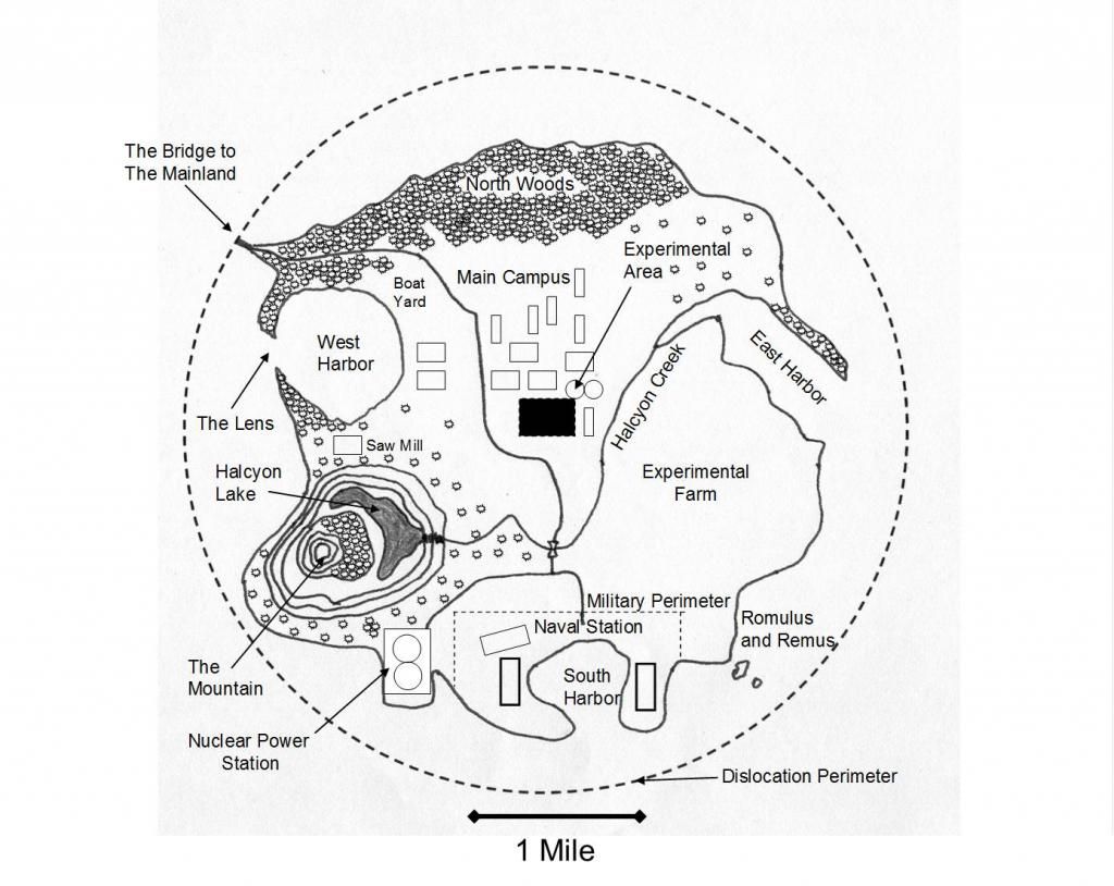
Shown in Figure 1 is one of the earliest maps that I created using a hand drawn sketch imported into PowerPoint® as a jpeg file. Additional features and text could then be added using the rudimentary graphics and text functions of PowerPoint®.
Although I still use this map today for the island University of Halcyon, I realized that this approach would not serve for the detailed maps I required of the new continent of Feiramar that had been discovered as the University of Halcyon was dislocated to a new world.
The hand drawn approach has many deficiencies. First of all, any modifications to the map either require a whole new map drawn from the beginning or a separate digital processing step to remove the inevitable erasure marks produced on modification. Secondly, the introduction of terrain and buildings is very tedious since each one must be added individually. Thirdly, it’s difficult to introduce colour into hand drawn maps.
I discussed this challenge with Jeff Gerke, a speaker at Write!Canada, and he pointed me to British gaming map software (Profantasy®) that could also be used for fantasy maps.
Let me insert a disclaimer. I am not visually artistic. I don’t regard map design as one of my strengths. At the end I will provide some links to maps created by gifted users of the software to give the reader a sense of the power of the program. Also I do not necessarily intend to recommend the software I use, but describe my journey as a help to other writers as they design their own maps.
When I first used Profantasy® software, I realized it was a very powerful map and city design tool. However the complexity, while enabling stupendously beautiful and detailed maps, required a long learning curve. I estimate it took me 20-30 hours of work until I was able to produce my first usable map. At many points in this learning process, I was stymied because I could not find the appropriate icon or could not introduce it into the map in the way that I required. There were many occasions, during this learning time, when I silently renamed the program “profanity software.”
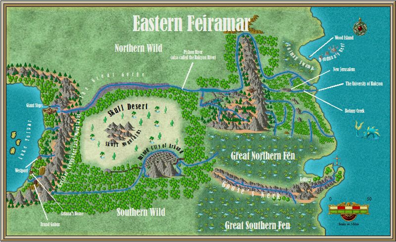
Figure 2 shows a map that I will be using in my upcoming sequel called The Battle for Halcyon. I found that learning the software was greatly accelerated by an excellent tutorial constructed by Joseph Sweeney which described how to build a full map from scratch and incorporate all the pieces I had been missing. If I had discovered Sweeney’s tutorial at the beginning, my learning curve would have been considerable shortened.
If you would like to look at some excellent maps, check out these links.
https://secure.profantasy.com/products/cc3_gallery.asp
http://forum.profantasy.com/comments.php?DiscussionID=2603
http://forum.profantasy.com/comments.php?DiscussionID=524
This software addresses the disadvantages of the hand drawn approach: emendations can be made easily; terrain and buildings are simple to add from a large library and can be added individually or in groups.
One of the advantages of this software for writers is the versatility. If one draws a large area map and then wishes to produce a number of blow-ups, one can use a subsection of a large map for a more detailed local map. When publishing a printed book, colour images are prohibitively expensive, so maps need to be rendered in greyscale black and white. However, since the same book is usually also available in e-book format, one would like the more spectacular colour image for the electronic version. If one simply exports a colour image to black and white, it is unlikely that the colour to greyscale translation will be optimized for map reading. Profantasy® contains an algorithm that accomplished this transformation satisfactorily.
In summary, I am hoping this discussion on mapmaking will generate some sharing of best practices. How do you make maps for your books? Have you found any software aids that make the process easier? I’d be grateful if you shared them.
Thank you for reading,
Peter
Have comments or tips on your own mapmaking strategies? Post them to the Word Alive Press Facebook Page!
About this Contributor:
Peter Kazmaier’s experience as a researcher in chemistry enables him authentic scientific insight to his books The Halcyon Dislocation, and Questioning Your Way to Faith. He lives with his wife Kathy in Mississauga. They spend their summers at their cottage on the Rideau Canal, near Seeley’s Bay, Ontario. His new book, The Battle for Halcyon, is in the final stages of editing and will be available shortly.
Peter’s Blog
Links to Books